A star in the universe, the sun is a giant nuclear fusion reactor. Combining hydrogen to form helium, the sun generates a great amount of energy. Radiation from the sun catalyzes or directly supplies most of the natural energy systems on earth. The sun causes the air in the atmosphere to warm up, setting temperature differentials that generate wind. Major patterns of winds are due to the earth's rotation about its axis and the day-night cycles of solar heating and subsequent cooling.
Figure 1: The Sun and the Earth (Crowther, Richard L., Sustainable Design, Sun-Earth)A great amount of energy is absorbed by the earth's surface itself, as well as by the oceans, plants and buildings. The energy absorbed by the plants is converted into food energy and from the oceans, evaporation causes the hydrologic conversion cycle.
Sun's Apparent Movement
The earth rotates around the sun. This causes the sun to "rise" and "set". The angle of the sun and its intensity on earth is affected by location of the place on the surface of the earth. The length of the atmosphere that the solar radiation has to pass through determines the amount of radiation that reaches the earth's surface. During the day, the sun is directly overhead and radiation travels through least amount of atmosphere enroute to the earth's surface. As the sun moves closer to the horizon (sunset), the path of the radiation through the horizon lengthens and the intensity of the radiation decreases. Also, at a high elevation, the amount of atmosphere that the solar rays have to travel through is lesser and therefore the energy content is somewhat higher.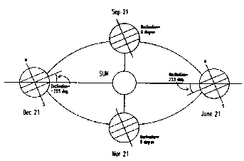
Figure 2: The tilt of the earth remains constant at 23.47o as it revolves around the Sun. (Mazria, Edward, The Passive Solar Energy Book)
Because of the earth's tilt and rotation, the length of atmosphere that solar radiation passes through varies with the time of day and month of the year. The path of the earth around the sun is a slight ellipse. As the earth orbits around the sun, it rotates on its axis that extends from the North pole to the South Pole every 24 hours. The axis is tilted 23.47o from the vertical to the plane of the earth's orbit around the sun
.
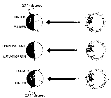
Figure 3: The tilt of the earth creates seasons on earth (Mazria, Edward, The Passive Solar Energy Book)
The earth's tilt is responsible for the seasonal variations in weather. The tilt is constant as the earth revolves around the sun. When the Northern Hemisphere is tilted towards the sun, the incoming radiation is closer to the perpendicular to the earth's surface and the duration of sunshine is longer. It is now summer in the Northern Hemisphere. At this time, there is winter in the Southern Hemisphere. When it is winter in the Northern Hemisphere, it receives fewer hours of sunshine, at a lower angle, while summer prevails in the Southern Hemisphere.
Geographical Location
The climate of a place depends on its geographical location.
Latitude
The Latitude is the angular distance measured along a meridian from the equator, North or South, to a point on the earth's surface. Any location towards the North is considered having positive latitude and towards the South as negative latitude. The North and the South poles are +90 and -90 respectively. Latitude values are important as they define the relationships with the sun.
Figure 4: Latitudes in the United States (Mazria, Edward, The Passive Solar Energy Book)
In VRSolar the latitudes of major world cities have been provided and can be chosen. Other values can be filled in by hand or selected from the map of the world. Refer Appendix C for the listing of latitudes.
Longitude
Longitude is the angular distance measured from the prime meridian through Greenwich, England, West or East to a point on the earth's surface. Any location West of the prime meridian is positive and any location East is negative.Astronomical Location of the Sun
Once the location of the site is determined, the position of the sun in relation to the site has to be determined. This geometrical relationship between the sun and the earth can be described by the latitude of the site, the time of the year, the time of the day the angle between the sun and the earth and the altitude and azimuth angles of the sun.Julian Date
Julian date is the number of days from the first day of the year. January 1 has a Julian Day of 1, December 31 has a Julian day of 365, except in leap years when it has a Julian Day of 366. Therefore the Julian Days can be calculated thus:month_index = month number -1
date_index = date - 1
function calcJDay(month_index,date_index) {
var j_day=0
var date_val=date_index+1
if (month_index==0)
j_day=0+date_val
else if (month_index==1)
j_day=31+date_val
else if (month_index==2)
j_day=59+date_val
else if (month_index==3)
j_day=90+date_val
else if (month_index==4)
j_day=120+date_val
else if (month_index==5)
j_day=151+date_val
else if (month_index==6)
j_day=181+date_val
else if (month_index==7)
j_day=212+date_val
else if (month_index==8)
j_day=243+date_val
else if (month_index==9)
j_day=273+date_val
else if (month_index==10)
j_day=304+date_val
else if (month_index==11)
j_day=334+date_val
return j_day
}

Declination Angle
The angle between the earth-sun line and the equatorial plane is called the declination angle. Declination changes with the date and is independent of the location. The declination is maximum (23.45) on the summer/winter solstice and 0 on the equinoxes.
Figure 5: The Declination Angles
The declination for a particular day can be represented by the formula:
23.45 * sin(( j_day_value+284) * 360/365)
where
j_day_value = Julian day value of the day
Hour Angle
The Hour Angle is the angular distance that the earth has rotated in a day. It is equal to 15 degrees multiplied by the number of hours from local solar noon. This is based on the nominal time, 24 hours, required for the earth to rotate once i.e. 360 degrees. Values East of due South, morning values are positive; and values West of due South, evening values are negative. The Hour Angle can be defined byHour Angle = 15 * (12 - hour)
where
hour is the current hour of the day.
Solar Altitude
The solar altitude is the vertical angle between the horizontal and the line connecting to the sun. At sunset/sunrise altitude is 0 and is 90 degrees when the sun is at the zenith. The altitude relates to the latitude of the site, the declination angle and the hour angle.sin(Alt) = cos(Lat) cos(Decl) cos(HAngle) + sin(Lat) sin(Dec)
where
Alt = Altitude
Lat = Latitude
Decl = Declination
HAngle = Hour Angle
In implementing in the program, the following was used:
sin_alt_r = cos(lat_r)*cos(decl_r)*cos(hour_r)+sin(lat_r)*sin(decl_r)
sin2alt = sin_alt_r * sin_alt_r
cos_alt_r = sqrt(1 - sin2alt)
altitude = atan(sin_alt_r / cos_alt_r) * TODEGREE
where:
sin_alt_r = Sine of altitude in radians
lat_r = Latitude in radians
decl_r = Declination in radians
lat_r = Latitude in radians
cos_alt_r = Cosine of altitude in radians
TODEGREE = Constant equal to 180/pi
The extra two steps to are added so that the altitude values are always calculated even when the sin of the altitudes may be negative. This insures that the formula does not fail at any point.
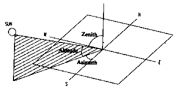
Figure 6: Solar Altitudes and Azimuths (Liang, June Lok-Mei, Computer Modeling of Cumulative Daylight Availability within an Urban Site)
Solar Azimuth
The azimuth angle is the angle within the horizontal plane measured from true South or North. The azimuth, when in reference to the South is usually called the bearing. If the sun is East of South, the Bearing is positive, else the bearing is negative.Alt = Altitude
Azm = Azimuth
Decl = Declination
HAngle = Hour angle
alt_R = Altitude in radians
azm_R = Azimuth in radians
lat_R = Latitude in radians
hour_R = Hour angle in radians
x_azm = x component of azimuth
y_azm = y component of azimuth
TODEGREE = Constant equal to 180/p
sin(Azm) = cos(Decl) sin(HAngle)
--------------------------------
cos(Alt)
This equation, however, fails at certain points, e.g. when the altitude is 90o. Another version of this equation is:
(cos(lat_R)*sin(decl_R)-cos(decl_R)*sin(lat_R)*cos(hour_R))
cos(azm_R) = -----------------------------------------------------------
cos(alt_R)
This equation too fails because of the same reasons. Therefore another equation was used which breaks the azimuth in its x and y components.
x_azm = sin(hour_R) * cos(decl_R)
y_azm = (-(cos(hour_R))*cos(decl_R)*sin(lat_R))+(cos(lat_R)* sin(decl_R))
azimuth = atan(x_azm/y_azm)*TODEGREE
This equation performs well in all the numbers and was used in the final version of the program.
Shadow Angles
Horizontal and vertical shadow angles describe the length of shadows on any wall surface.
Figure 7: Horizontal and Vertical Shadow Angles (Bansal et al., Passive Building Design, A Handbook of Natural Climatic Control)
Horizontal Shadow Angle
The horizontal shadow angle is the difference between the wall azimuth and the solar azimuth
HSA = Azm - Ori
where
HSA = Horizontal Shadow Angle
Azm = Azimuth
Ori = Orientation (Azimuth of the Surface Normal)
Vertical Shadow Angle
VSA = arctan (tan(Alt)/cos(HSA)
Solar Diagrams
For each site, this relationship can be graphically represented through the sun-path diagrams for a site. At any time of the year and day, the exact location of the sun can be determined through a combination of two values, the altitude and the azimuth.Stereographic Sun Path Diagram
The Sun Path Diagram represents the position of the sun based on the altitude and the azimuth. This diagram is the stereographic projection of the sun path (view of the sky on an horizontal plane). The radial line shows the solar azimuth and the concentric circles, the solar altitude. From these graphs, it is easy to find out the position of the sun at any time and day for a given location.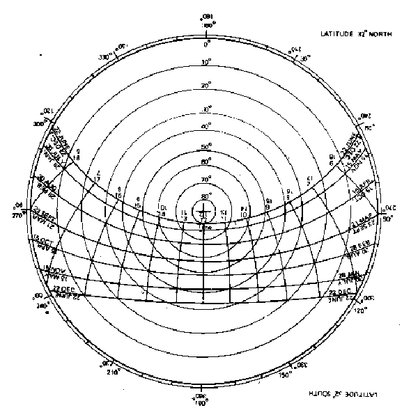
Figure 8: Stereographic Sun Path Diagram for 32o latitude. Read from this side the Diagram represents 32o North. Upside down, it represents 32o South. (Koenigsberger et al., Manual of Tropical Housing and Building, Climatic Design)
Cylindrical Sun Path Diagram
Another kind of Solar Diagram, the cylindrical diagram was developed by Edward Mazria. This chart is a vertical projection of the sun's path as seen from the earth. It could be said that this chart is an earth base view of the sun's movement across the skydome.
Figure 9: Explanation of the Cylindrical of Sun Path Diagram (Mazria, Edward, The Passive Solar Energy Book)
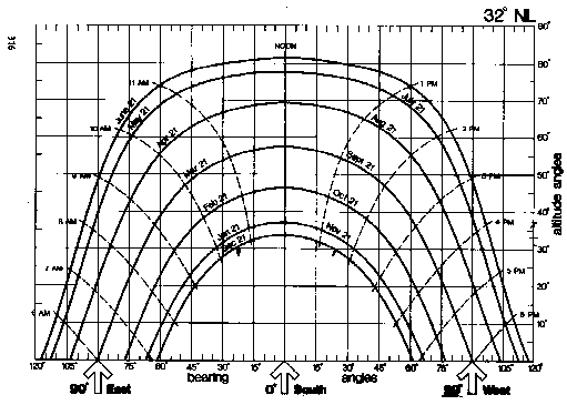
Figure 10: Cylindrical Sun Path diagram for 32o North. (Mazria, Edward, The Passive Solar Energy Book)
In the Cylindrical Sun Path Diagram, the bearing is marked at the base, and the altitudes on the vertical axis. The location of the sun can be determined by intersection of the altitudes and the azimuths. A very important use of this rectangular chart is that surrounding buildings can be plotted at define exactly when the sun would go behind those obstructions.
This chart is used in VRSolar to graph out the positions of the sun for a selected location. Using VR, the Tool makes it possible to simulate this chart and get the view of the sun as it moves through the sky.
Solar Envelope
The Solar Envelope is defined as the maximum built volume on a site such that it does not block direct sun to its neighbors in specified times. As buildings become taller and densities increase, the sun access to buildings decreases and the maximum buildable volume of the site approximates a pyramid.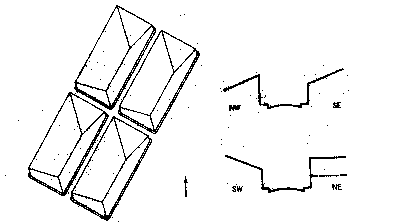
Figure 11: Solar Envelopes define the maximum buildable volume of a site. (Stein, Benjamin et al, Mechanical and Electrical Equipment for Buildings)
VRSolar aims to add solar envelope calculations in its future versions.
Shadows:
In a three-dimensional view, shadows explain the locations where there is no sun. In another sense, all that the sun does not "see" is in shade. VRSolar uses this concept of the sun's view. The VRML scene provides views from the sun at selected times which indicate the surfaces that are lit by the sun. Though this notion comes about from the limitation that VRML, cannot calculate real time shadows yet; none the less the idea of looking at the site from the sun's perspective is not only interesting, but also informative.Copyright © Archit Jain, USC School of Architecture, 1997. All Rights Reserved.
Last Modified: 03/22/2011 01:45:20. This page is part of the Online Solar Position Calculator and VRML Builder--VRSolar.
Figure 9: Explanation of the Cylindrical of Sun Path Diagram (Mazria, Edward, The Passive Solar Energy Book)
Figure 10: Cylindrical Sun Path diagram for 32o North. (Mazria, Edward, The Passive Solar Energy Book)
In the Cylindrical Sun Path Diagram, the bearing is marked at the base, and the altitudes on the vertical axis. The location of the sun can be determined by intersection of the altitudes and the azimuths. A very important use of this rectangular chart is that surrounding buildings can be plotted at define exactly when the sun would go behind those obstructions.
This chart is used in VRSolar to graph out the positions of the sun for a selected location. Using VR, the Tool makes it possible to simulate this chart and get the view of the sun as it moves through the sky.
Solar Envelope
The Solar Envelope is defined as the maximum built volume on a site such that it does not block direct sun to its neighbors in specified times. As buildings become taller and densities increase, the sun access to buildings decreases and the maximum buildable volume of the site approximates a pyramid.Figure 11: Solar Envelopes define the maximum buildable volume of a site. (Stein, Benjamin et al, Mechanical and Electrical Equipment for Buildings)
VRSolar aims to add solar envelope calculations in its future versions.
Shadows:
In a three-dimensional view, shadows explain the locations where there is no sun. In another sense, all that the sun does not "see" is in shade. VRSolar uses this concept of the sun's view. The VRML scene provides views from the sun at selected times which indicate the surfaces that are lit by the sun. Though this notion comes about from the limitation that VRML, cannot calculate real time shadows yet; none the less the idea of looking at the site from the sun's perspective is not only interesting, but also informative.Copyright © Archit Jain, USC School of Architecture, 1997. All Rights Reserved.
Last Modified: 03/22/2011 01:45:20. This page is part of the Online Solar Position Calculator and VRML Builder--VRSolar.
This is incredibly beautiful. Thank you for your hard work.
ReplyDeleteI can't find anything out about VRSolar online. I keep getting directed to a battery company. What is it? Where can I get it?
ReplyDelete